A new way to up-country hills - Sri Lanka

Up-country hills - Sri Lanka via Fool's Bridge Ulapane, Kothmale, Raja Pihilla, Pundaluoya, Dunsinane Falls and Talawakelle.


In this article, we mention two alternative vehicle routes to upcountry hills via Karawanella, Kothmale, and Pundaluoya, starting from Colombo, rather than the traditional Nuwara-Eliya route via Kandy or Ella.


Route Number 01
1. Colombo
2. Awissawella
3. Dehiowita
4. Karawanella
5. Kithulgala Water rafting

There are several water rafting spots in Kitulgala. You can have a better water rafting experience from the experienced experts here, who conduct rafting on this Kelani River.


6. Laxapana Waterfall

This is one of the stunning waterfalls in Sri Lanka. There are two ways to reach it.

1.       From Diyagala junction        

      Diyagala Junction is located in Watawala area on Colombo-Ginigathhena-Hatton main road. At Diyagala Junction, turn towards Norton Bridge Road. Along this road, you will encounter Dehigastenne, Norton Bridge, Kiriwaneliya and the 04th Mile Post Junction. Turn right at the 04th Mile Post Junction towards Laxapana Waterfall, and continue for approximately 2.2 kilometers to reach your destination. Between Norton Bridge and Kiriwaneliya, you can find a unique and remarkable landmark known as the 0’s milepost. It is the only 0’s milepost tower in Sri Lanka. The journey consists of nearly 17 kilometers from Diyagala junction to the waterfall.

2.       Kalugala junction

This junction is located between the towns of Yatiyanthota and Ginigathhena on Colombo-Hatton main road. Turn towards Polpitiya road at Kalugala junction. Continue along the road and turn right at Bodigara junction in Polpitiya. The road is much more challenging. It's nearly 18 kilometers to the destination from Kalugala junction.

Kelani River flows through Laxapana waterfall, originating from Samanala Mountain also known as Sri Pada mountain. Laxapana waterfall is the 8th highest waterfall in Sri Lanka, standing at 126 meters in height.


7. Ginigathhena Town

Ginigathhena is one of the most stunning towns in Sri Lanka.


8. Nawalapitiya


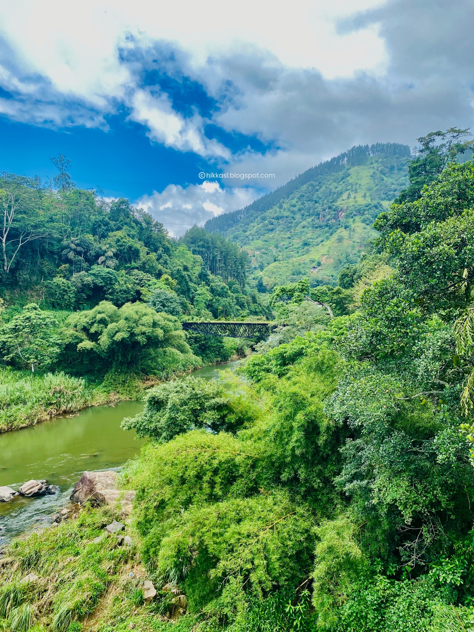
9. Ulapane Fool’s bridge

This is one of the most valuable bridges in Sri Lanka, built-in or around 1904. 


Why is this bridge so special? It features a rare upside-down design, making it unique in the world. However, some people believe that the uncommon bridge structure presents a problem, leading to its nickname, "fool’s bridge". Mahaweli River is flowing under the bridge. No one is crossing the bridge, it has become difficult to even enter. 


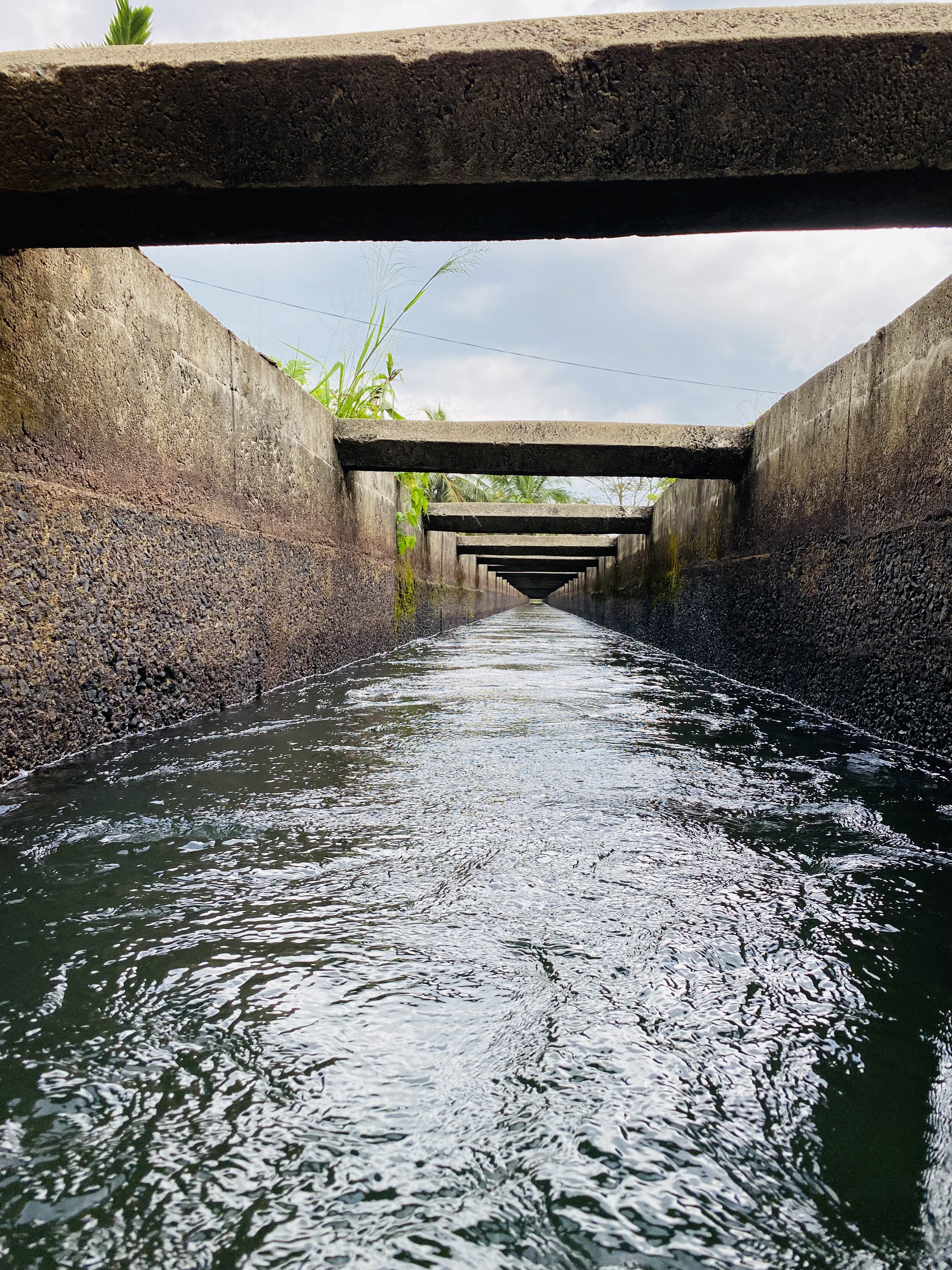
10. Kothmale Dam & Information Centre

You can view the dam from both Thispane and Kadadora mountains. However, in this article, we will focus on the information from Kadadora viewpoint, located on the road towards Ranamune and Pundaluoya from Ulapane junction.

The dam, which spans 600 meters and connects Kadadora and Thispane mountains across Kothmala Oya, is a remarkable feature of this route. At the midpoint of the dam, you can see Ramboda waterfall and Karnagala mountain peak point which is a very popular camping spot.

Kothmale Dam information center is located approximately 600 meters away from the dam towards Ranamune on Ulapane - Pundaluoya main road. All the information about the project is available at the center.


11. Dehadukadulla Historical Point

This is a historical place, further, a historical gate. When Prince Dutugemunu entered Kothmale village through this gate as a single person, it is said that he hid his sword at this gate. The gate is situated nearly 200 meters away from the information center towards Ranamune.


12. Ranamune Raja Pihilla

What a beautiful place!


This location holds historical significance in Sri Lankan history. It is where Prince Dutugemunu bathed during the time he lived here. Located approximately 07 kilometers away from Dehadukadulla historical point, towards Pundaluoya. Raja Pihilla (bathing point) is situated 200 meters away from the main road, and it is visible from the road.


Visitors are also allowed to bathe there.


13. Dunsinane Falls

This waterfall is one of the most stunning and attractive waterfalls in Sri Lanka. It is located in Pundaluoya village, just 3 kilometers away from Pundaluoya-Kothmale main road. The waterfall is formed by Pundaluoya River, which is a tributary of the Kotmale Oya.


14. Upper Kothmale Dam

This hydroelectric power station is the third largest in the county, with a capacity of 150MW generated by two 75MW turbines. The water released from the Upper Kothmale reservoir flows directly into the Kothmale reservoir. The dam was opened in 2012.


15. St.Clair Falls viewpoint

The St. Clair waterfall is one of the stunning waterfalls in Sri Lanka, located a short distance from Thalawakelle town towards Hatton. Following the Upper Kothmale Dam’s completion, the waterfall’s water level dropped. However, it currently releases a single water outlet to function the waterfall. 


16. Nanu-Oya Waterfall

What a beautiful scenery!


Situated in Nanuoya village. Nearly 1.3 kilometers away from Nuwara-Eliya – Hatton main road. You can see the railway track above the waterfall.


17. Glassaugh falls

Just a few away from Nanu-Oya waterfall. 

-------------------------------------------------------------------------------------


Here are some breathtaking spots that you can see along the road.


(Between Ranamune and Upper Kotmale)


(between Thalawakelle and Nuwara Eliya)


(between Thalawakelle and Nuwara Eliya)


(Night view of Nuwara Eliya Town)


(Gregory Park Nuwara-Eliya)


(Gregory Park Nuwara-Eliya)


(Seetha Amman Kovil Nuwara-Eliya)


----------------------------------------------------------------------------------------------------


Route Number 02

How does this route differ from the 01st route?

This route has an amazing waterfall path between Karawanella and Nawalapitiya towns, but is otherwise the same as the first one.

In the first route, we headed to Kitulgala from Karawanella junction. But on this route, we are heading to Bulathkohupitiya from Karawanella junction. Turn onto Dedugala road at Bulathkohupitiya junction and you'll encounter one of the most wonderful roads in Sri Lanka, adorned with numerous waterfalls.

1.       Weladha Ella waterfall

2.       Rikili Ella waterfall

3.       Nalagana Ella waterfall

4.       Rukmal Ella waterfall

5.       Dedugala town

6.       Diyagiri Ella waterfall

7.       Palampitiya Viewpoint

8.       Windsor forest waterfall

9.       Dolosbage town

10.   Dethiri Ella waterfall,

then,

11.   Nawalapitiya town

In this route also we pass through Nawalapitiya once again, just like on the first route.


--------------------- The End --------------------- 

Things to do in Deniyaya and the suburbs | Sri Lanka

Things to do in Sinharaja and Deniyaya | Patna Sliding Rock adventure  


Patna Sliding Rock, Sinharaja Rainforest and Deniyaya 

Sinharaja Forest Guide - Click Here 

How can I get to Deniyaya?

If you are coming from Colombo, take Welipenna interchange exit on the southern expressway, then follow the directions to Pelawatta, Neluwa, Morawaka, Kotapola, and Deniyaya. If you are coming from Galle, Hikkaduwa, Unawatuna or Matara, there is a direct road to Deniyaya via Akuressa or if you are coming from Kandy, Nuwara-Eliya, Ratnapura or Ella, you need to go to Madampe junction and get directions to Deniyaya via Rakwana which is one of the most stunning roads in Sri Lanka.


Deniyaya Bus Station


Deniyaya Tourist Information Center

This is located next to the Bus Station.


Patna Sliding Rock

This location is located approximately 08 kilometers from Deniyaya town in the direction of Ensalwatta via Kosmulana junction. You can reach very close to Patna sliding rock by using your own vehicle or a motorbike, but it is recommended to use a four-wheel drive vehicle.  


The road is much more difficult to drive. Instead, there are two or three vehicle parking areas on the main road (Updated: May 2024). You can park your vehicle and walk approximately 2.8 kilometers from there. From a specific parking area, there is a shuttle service to the sliding rock if you are unable to walk. You can utilize this service for assistance. If you are walking, you need to continue along the main road and turn right at Kosmulana junction. Then, after the bridge, turn left onto the village road and the destination will be at the end of this road.   


You need to purchase a ticket from the ticket counter just before the sliding rock to enter the area. Restroom and clothes changing facilities are available. The entire journey takes at least 3 hours from Deniyaya town.

I highly advise against leaving Deniyaya without visiting Sinharaja.

It's best to spend the night at a cottage or a villa on Pallegama-Mederipitiya road, which is nearly 10 kilometers from Deniyaya town towards Sinharaja. There are numerous luxury villas and cottages in the area. This way, it is easy to start your walk at next day to Sinharaja early in the morning.

Below, will outline the easiest way to explore the rainforest, leading up to Kekuna Ella waterfall, where you can take a refreshing bath within half a day.


Pitadeniya Entrance to Sinharaja


To access this entrance, you need to park your vehicle at a private parking area owned by a villager before the entrance and walk about 200 meters to the Pitadeniya entrance. (Updated: May 2024) Alternatively, if you are staying nearby, you can park at your accommodation and walk to the entrance. The road is a single-lane concrete road.   


Pitadeniya Entrance ticket counter


You need to purchase tickets at the counter. Authorized travel guides are available at all the entrances and you must pick up a travel guide even if you are traveling alone.

Starting from Pitadeniya entrance, you will be walking along the border of the Sinharaja rainforest with Gin Ganga (Gin River) on your left-hand side as step 01. Our walking pathways are on the right bank of the river. Along the way, you will encounter small waterfalls, indigenous insects and animals as well.

Step 01 walking path ends at Wathugala entrance which is nearly 1.7 kilometres from Pitadeniya entrance. You don’t need to buy tickets again but you have to show the tickets you bought at Pitadeniya entrance to the ticket counter at Wathugala entrance.

There is a three-way junction on the path approximately 1.4 kilometers from Pitadeniya entrance before Wathugala entrance. You will find the below signboard at the location.


Sinharaja Conservation Center

If you take a left turn at the three-way junction, you will find the pathway to Sinharaja Pitadeniya Conservation Centre which is located on the left bank of the Gin River. There is a suspension bridge over Gin River that leads to the conservation center where you can find an information center as well.

Suspension Bridge


Conservation Center


You can even drive your vehicle up to here. You have to drive your vehicle from the unknown junction located on the Deniyaya – Lankagama road. If you are coming from that direction towards Sinharaja, you should park your vehicle at the Pitadeniya Conservation Centre. Then, you need to cross the suspension bridge from the left bank to the right bank of the Gin River and head to the three-way junction mentioned earlier. You need to purchase tickets at Wathugala entrance.


Wathugala Entrance


This is the next entrance to Sinharaja along our walking route, and it is also the entrance for people coming from Lankagama area. Why do we need to cross this entrance? because our route follows the border of the forest, and all the other entrances are connected to the border. We are still going on the border instead going inside of the forest because our destination, Kekuna Ella Waterfall is on the border.

Kekuna Ella waterfall is located just 500 meters away from Wathugala entrance.


How do you reach Wathugala entrance by your own vehicle?

There is a three-way junction next to Lankagama bridge towards Neluwa on Deniyaya – Lankagama - Neluwa road. You can get very close to Wathugala entrance by turning right at that junction. While you can ride a bicycle on that road, but cannot guarantee that a vehicle can pass through.

You don't need to worry about the junctions within the forest because a travel guide will always be there to guide you.


Our Destination, Kekuna Ella Waterfall


This waterfall is nearly 10 meters high and has an elevation of 276 meters above sea level. It is located on the border of both Galle and Matara districts. This is a safe place for swimming and guides will always be available to assist you. People also swim on the upper level of the waterfall, but the path to reach is much more difficult.


From Pallegama junction to Neluwa via Lankagama

This road is one of the most breathtaking routes in Sri Lanka, spanning nearly 25 kilometers.


From Pallegama junction, continue for 2 kilometers along the road and then turn right at a three-way junction onto a single lane road leading to Dambagoda Bridge. Follow this road for about 20 kilometers, passing through Lankagama, Warukandeniya, Madugeta, Thamabalagama Maithree Viharaya, Neluwa Doovili Ella three-way junction and continue on the Kosmulla-Lankagama road until you reach Neluwa bridge. (Make sure to turn right on Madugeta junction because there is a bridge on the left road but it is uncertain whether vehicles can pass through). It is better to ask someone on the road as the road may not be updated on the maps yet.

Tip: Turn on directions from Pallegama Junction to Neluwa and turn the travel mode to ‘Walking’ on Google Maps.


The road is safe and not difficult, and it is suitable even for the vehicles with low ground clearances. Along the journey, you will come across Lankagama entrance of Sinharaja and a waterfall called Brahmana Ella Waterfall, which is very close to the road.


Brahmana Ella Waterfall


There are three waterfalls near Lankagama entrance within the forest that you can visit: Thattu Ella Waterfall, Gal Oruwa Ella Waterfall and Doowili Ella Waterfall Lankagama. It's worth noting that there are two waterfalls called Doowili Ella in Sinharaja. Gal Oruwa Waterfall is the farthest from Lankagama entrance, located only 500 meters away.

There is a designated vehicle parking area available at the entrance. (Updated: May 2024)


                                                                          ---- The end ----


The Best Tourism Routes in Sri Lanka via Kandy, Ella, Udawalawa , Yala , Madunagala hot water springs, Hiriketiya, Mirissa and Unawatuna


1.       Colombo and surrounding area

2.       Pinnawala elephant orphanage

3.       Temple of the Tooth Relic Kandy and the surrounding area

4.       Ella and the surrounding area

5.       Udawalawe National Park

6.       Sacred city of Kataragama

7.       Yala National Park

8.       Madunagala hot water springs

9.       Muruthawela canal bathing point / sliding point

10.   Dikwella and surrounding area

11.   Mirissa and the surrounding area

12.   Surfing Point Weligama

13.   Unawatuna beach cafes and restaurants

14.   Galle fort

15.   Hikkaduwa corals

16.   Again Colombo

Below pictures will show you the route starting from Colombo-Pettah market to Yala National Park via Pinnawala, Kandy, Ella, Udawalawe National Park and Kataragama. 


Here is the route again to Colombo starting from Yala National Park via Madunagala hot water springs, Muruthawela canal sliding point, southern and south-west sea beach area.


Colombo and Surrounding Area

Modern Colombo - You have plenty of opportunities to explore the city, with numerous star-rated hotels, restaurants, and cafes. The area boasts sunny weather, and tourists particularly enjoy strolling through the streets in the evenings, especially near Galle Face Ground.


Galle Face ground – In the evening, both locals and foreigners can be seen walking around the area, enjoying the beautiful scenery of the sunset and indulging in local street foods. Occasionally, locals gather here to celebrate kite festivals. The walkway near the beach extends towards Port City. Port City is a newly constructed city in the sea adjacent to Galle Face ground. In Port City, visitors can enjoy walking along the path, go-cart driving, and breathtaking views during the early morning and evening hours.

Pettah market – Sri Lanka’s largest market ever. You can buy anything you want such as plastic items, electronic items, electrical items, computer accessories, mobile phones and accessories, dressing items, household items, shoes, clothes, food items, vegetables, fruits, lighting items, types of decorations, bags, etc. There are sets of streets in Pettah market famous for particular items. However, there is an issue of sustainability of some sensitive items in there. 

The below list will show the streets in Pettah and what they are famous for. 

·         Prince Street – Dutch museum. The only remaining Dutch building in Pettah

·         Bodhiraja Street – Clothes, food stores, various kinds of spicy food and so on

·         Dam Street – Stainless steel items, plastic items, cake tools

·         Wolfendhal Street – Electronic or non-electronic scales, kind of oils

·         Sea Street / Hetti Weediya – Jewelleries

·         Main Street – Sarees, cloth stores, all government and private banks, especially the world-famous Jami Ul-Alfar Mosque aka Red Mosque is situated there.

·         China Street – Chemicals, party items, plastic items, polythene items

·         St. John Street – Cashew stores

·         1st Cross Street – Mobile phones and accessories, electric items, computer items

·         2nd Cross Street and Keyzer Street – Shoes, bags, cloths, carpet, curtains

·         3rd Cross Street – Industrial items such as screws, scales, and so on

·         4th Cross Street (the busiest street) – Food items

·         5th Cross Street – Vegetable stores, rice mills

·         Maliban Street – Stationery items, paper decorations and items made by papers

·         Malwatta Street – Bags and related items, shoes, watches, DVDs

·         Prince Street – Toy stores, mirror stores, glass stores

·         Bankshall Street – Handy crafts materials


Pettah floating market – This market is on the water. There is a small lake near Pettah bus station and this market is built on that lake. Snack bars, cafes, restaurants, dining areas and lavatory facilities are available there.   

Aluthkade street food - You can taste famous street food till midnight in Aluthkade area. Various kinds of food and beverages in there.   

Make sure to visit the Hindu Kathiresan Temple on Sea Street.


Pinnawala Elephant Orphanage

One and only elephant orphanage in Sri Lanka situated very close to Rambukkana town.

Pinnawala Zoo – Situated closer to the elephant orphanage.


The Temple of the Tooth Relic Kandy and the suburbs

Temple of the Tooth Relic Kandy – This is the most treasured tooth relic that belongs to the Buddhists. Hundreds of locals and foreign visitors come to visit every day and they feel the serene atmosphere. Additionally, the Kandy Esala Perahera, aka a grand procession is one of the most ceremonial festivals in Sri Lanka that takes place every July.


Lake round and streets – You can walk along the streets in Kandy especially the lake round enjoying beautiful scenery even in the afternoon since it has calm and cold weather in the daytime there. There are plenty of star-rated hotels, restaurants, cafes and shopping malls within the city.

Make sure to visit Kandy's city viewpoint on Rajapihilla Street.

Peradeniya Botanical Garden – Beautiful walkways, benches and Sri Lanka’s indigenous plants can be seen here. Sri Lanka’s largest river, river Mahaweli is the boundary of the garden. Calm weather and calm environment.


Ella and the Surrounding Area

Ella is one of the most beautiful places in Sri Lanka and one of the places where you can breathe pure oxygen in the world. Ella town, Ravana Falls, Nine-Arch Bridge and Demodara railway loop (Rail bend) have become the main reasons for attracting local and foreign people. Basically, the weather is very calm without much more heavy showers or even sunny.

Ella-Rock Hike, which is very much loved by people who go hiking and camping in Sri Lanka.

·         Nine arch bridge – Click Here

·         Demodara railway loop - Click Here

·         Ella Rock Hike – One of the most famous hiking ranges in the world. Click Here


Udawalawe National Park

The park is especially for seeing the elephants. Early morning and the evening are the best for safari and scenery. One side of the park is completely covered by Udawalawe reservoir. You can complete the safari within half a day. 


Kataragama Stupa aka Kirivehera

Stupa and the God of Kataragama - Kataragama Kiriwehera aka Kataragama Stupa is the only stupa in the world built during the lifetime of Lord Buddha. Manik river is a partial boundary of the sacred city. Thousands of locals come to Kataragama to worship every day. Kataragama procession continues for 15 days in July every year. Click here to read more:


Yala National Park

This Park boasts the world’s highest leopard population density. The park's boundaries are home to a variety of reptiles, amphibians, etc.

Lots of locals and foreign people come here to see the elephants, leopards, deer, and kind of birds and more. There are several entrances to the park, especially the four-wheel drive safari vehicles available at the entrances. You can complete the whole journey within half a day. Better if you could visit early in the morning or afternoon till the evening. Click here to visit:


Tissamaharama Ancient Temple and Stupa

Tissamaharama Raja Maha Viharaya and Stupa – This belongs to the kingship era in past Sri Lanka. Why this is important? The Stupa was built by King Kawanthissa in the second century BC. This area became the old capital of Ruhunu division in the kingship era in the third century of AD. Lots of people make sure to worship this temple and the Stupa during their travels to Kataragama.  

Tissamaharama lake – This lake’s early morning and evening sceneries must be one of the best sceneries presented by nature to the people in the world. The way from Hambantota to Kataragama via Tissamaharama is going through the dam of this lake. Vehicle parking slots are available within the way on the dam. 


Madunagala Hot Water Springs

This location is situated in a village called Madunagala in Hambantota district closer to Padalangala – Sooriyawewa main road. There are several hot water springs in the location and they have kind of different temperatures. The location’s surrounding area is very sunny probably the whole year. You can feel the nature of a real Sri Lankan village there.


Muruthawela Canal bathing point/water sliding point

This is an uncommon hidden place situated in a village called Muruthawela in Hambantota district. The nearest city is Walasmulla.


These two canals are the outlet of Muruthawela reservoir which always carries water to the farming in the suburbs. You can bathe or slide in the canals in there. 


Dikwella and the Surrounding Area

Hummanaya Blowhole – Click here to visit:

Blue Beach Island – This is a private camping island that is connected to the mainland by a sandway. There are several camping sites in there. To reserve the campsite, you can inquire with the owner of the island.

Nilwella beach – Ideal place to feel the sunset. Less crowded and one of the best places to go snorkeling and swimming. But make sure to get a guide.   

Hiriketiya beach – This is also an ideal place for mind relaxing. Hiriketiya Bay is a trendy surf area. Several surf schools there. Surfboards are available for rent. The location is safe but make sure to get a guide.


Mirissa and the Surrounding Area

Coconut Tree Hill Mirissa - One of the most famous and unique destinations in down-south Sri Lanka. Thousands of locals and foreign people come here to see the scenery combined with the red floor.

Mirissa whale watching – There are plenty of clubs that offer whale-watching packages in there. You can contact any club and they will organize a journey for you. The journey will start early in the morning and most probably you will have your breakfast on the boat. It takes 05 or 06 hours to complete the trip.


Surfing Point Weligama

Weligama bay is the ideal place for beginners who are willing to learn surfing. Hundreds of locals and foreigners are daily arriving here to experience the sport. Beach and the sea waves are small and continuously occur which is perfectly fitted for beginners to their surfing career.


Unawatuna Beach cafes and restaurants

Stunning beach. Ideal location for snorkeling and swimming. There are plenty of eateries, cafes, and villas facing the beach. Unfortunately, from the main road to the beach, the road's approach is constrained. Therefore the available parking spaces are low. Your car can be parked on either side of the street if you are only enjoying the beach without booking a villa there.


Dewata - Surfing and bathing area


Unawatuna Jungle Beach – bathing point


Galle Fort

The best location for relaxation and sunset viewing. There are a number of star-rated hotels, villas, eateries, pubs and retail establishments there, particularly jewelry and gem stores. Parking slots and areas are available. The city inside the fort is almost entirely made up of Colonial architecture. Read the history of Galle Fort:


Galle Fort at night


Hikkaduwa Corals

Things to do in Hikkaduwa: Hikkaduwa Marine National Park, Hikkaduwa corals & Hikkaduwa diving. Visit here:

Conch Ship | What is this? - The ship was built in the United Kingdom in 1892. The ship struck the coral by accident on the 02nd of June in 1903 while traveling to Madurai. The location is 08 kilometers North of Hikkaduwa beach and 02 kilometers from the sea at Akurala point. ReadMore:

                        ----------------------------------------------------------------------------


Sri Lanka is a popular tourist destination, and the route from Colombo to again Colombo via Kandy, Ella, Tissamaharama, Dikwella, Unawatuna and Galle is one of the best. 

In this article, we highlighted some of the most eye-catching and ideal places to see along this route.